Khayelitsha, the 'new home'Khayelitsha, or ‘new home’ in isiXhosa, is the second largest township in South Africa after Soweto in Johannesburg. It is situated on the periphery of the city of Cape Town (30-35km from the CBD) and next to the N2 leading into Cape Town. Officially established in 1983, Khayelitsha was constructed to resettle African residents from the Western Cape. Khayelitsha was proposed to be 1070 hectares with four ‘towns’, each made up of four villages of 1500 residents per village. The original planned population size was 200,000 people, this was subsequently doubled to 400,000 people by 2011.
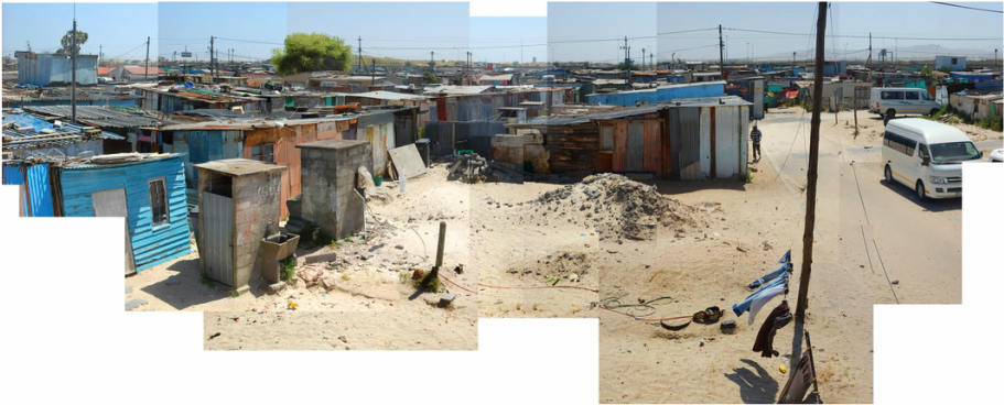
Today Khayelitsha is home to an estimated 2,400,000 people and consists of a minimum of 22 separate settlements. It has the largest single concentration of informal settlements in the City many of which are located on land that is unsuitable for housing as a result of flooding. There is a continued growth in shack numbers, estimated at 10 000 per annum. Khayalitsha is characterized by old formal areas and new informal/formal areas. The old formal areas built originally by the apartheid government include: Bongweni, Ikwezi Park, Khulani Park, Khanya Park, Tembani, Washington Square, Graceland, Ekuphumleni and Zolani Park. The newer areas have been built up around the older areas (sprawling expansion) and include: Site B, Site C, Green Point, Litha Park, Mandela Park, Makaza and Harare. With the exception of Litha Park, these areas contain a high number of informal settlements (64.4% of households in Khayelitsha live in informal dwellings), RDP houses, and informal backyard dwellings (mainly shacks). The most recent informal settlements in Khayelitsha include QQ Section, TR Section, RR Section and Enkanini. Housing varies from formal state (RDP) houses on a separate stand, informal housing in the backyards of the formal houses, and, the majority, shacks in informal settlements. DEMOGRAPHIC PROFILE Population Size: 2,400,000 inhabitants (Wikipedia 2021) Racial composition: Approximately 90.5% Black African, 8.5% Coloured, 0.5% White Gender Profile: The female to male ratio in this node is skewed towards females with women forming 52% of the population in Khayelitsha Population Density: 7748 inhabitants / km² (2005) Estimated 55,159/km² (2020) Household Size: Most households are relatively small with 69.3 % of households consisting of 4 people or fewer (City of Cape Town, 2005). Employment Status: Unemployment rate is 54.1% (compared with an average of 29.9% for Western Cape) Poverty Indicators: 71.8% of households earn below the HSL SERVICES The 2005 stats quoted here show the lack of services.
CURRENT AREA DEVELOPMENT Development challenges include:
INVESTMENT Current investment projects include the Khayelitsha Urban Renewal Programme: The area is undergoing changes as a result of the R1.5-billion Urban Renewal Project. Some of the projects being undertaken include new formal housing delivery in Mandela Park comprising two to three- bedroomed houses for middle-income families (prices ranging from R307 000 – R417 000). Further planned interventions by the City of Cape Town include:
Sources: www.alhdc.org.za/static_content/?p=91 www.wikipedia.org |
Quick stats
In 2023, we note the impact of COVID-19, ongoing loadshedding and rising food prices - evidenced by increased food insecurity, gender-based violence and escalating crime rates. |